Vegetation Survey Report of Grassland Restoration Field
Darcy McDowell and Alexandra Roldos; Caumsett Foundation Environmental Interns
Edited by S.Feustel, Caumsett Foundation Environmental Chairperson
July 2021
Purpose
To assess the progress of the Caumsett Foundation’s Grassland Restoration Project by summarizing and analyzing data collected during the annual vegetation transect.
Introduction
In 2010, The Caumsett Foundation in partnership with the NYS Office of Parks Recreation and Historic Preservation initiated a 30-acre grassland restoration project located at Caumsett State Historic Park Preserve. Vegetation composition was documented and analyzed prior to the restoration and continued each subsequent growing season to guide management strategies. Percent composition of specific vegetation categories were recorded and analyzed for the purpose of determining the percentage of invasive plant species compared to other relevant plant groups or categories. Click here to learn more about the Caumsett Foundation’s Grassland Restoration Project.
From 2010 to 2018 two transect methods have been used; the line transect and the walkabout. The line transect method was employed up until the summer of 2018. A vegetation analysis was not conducted in 2019. For each method the field was sampled in 3 separate 10-acre plots. When using the line transect method a quadrat was dropped at 50 foot intervals along a line bisecting each of the 3 fields in an east to west orientation. The percent vegetation composition within the quadrat was recorded at each interval. In 2020, the walkabout method was used in an attempt to sample areas not quantified by the line transect. This method used a central point within each of the 3 fields where 18 sampling points were located by taking a random number between 0 and 360 to give a compass bearing followed by another random number to provide the number of paces taken in that direction. Compass points and paces at each of the random points were reached in succession and percent composition was recorded. In 2021, a modified walkabout transect method was developed in an attempt to provide a more accurate representation of the vegetation composition. Data from this transect was collected from 7 June 2021 to 10 June 2021 by environmental interns Alexa Roldos (AR) and Darcy McDowell (DM).
Procedure
1. Baseline Data Collection
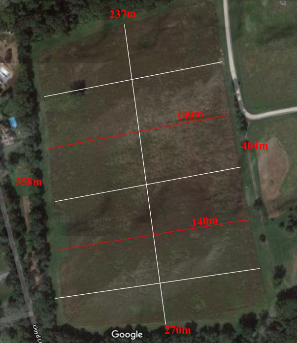
The perimeter of the 30-acre Grassland Restoration Field was measured using IOS Measure smartphone application. The entire field was then divided South to North into three smaller sections of approximately 10 acres each; Field 1 (South), Field 2 (Middle), and Field 3 (North). Center points for each of the three fields were marked with surveyor’s tape and recorded using coordinate pairs collected from smartphone location data (Figure 1).
Figure 1: Grassland Restoration Field baseline measurements. The perimeter of the 30 acre field was measured, and then divided into three 10-acre fields. The boundaries of each field were measured by dividing the longer (eastern) side into three 135 m sections. A center point for each of the three fields was established by halving the distance in each field (68 m). The northern and southern boundaries were bisected providing a central line running north to south through the three fields.
Figure 1
2. Modified Walkabout Transect:
Twelve compass bearings between 0 and 360 and 12 distances between 0 and 137 were randomly generated using a random number generator and recorded onto the Grassland Restoration Field data form (Figure 2). Starting at the center point of each field, AR would use a smartphone compass application to indicate the bearing while DM would measure out the distance using the IOS measure app. Once the indicated distance was reached in the direction provided by the randomly generated pairs on the data form, the quadrat was dropped and the coordinates were recorded. If the distance exceeded the boundary of the field, the distance traveled was recorded and the quadrat was dropped at the boundary of the field. Each subsequent data collection point was reached from the marked center point of the field being surveyed.
The composition of plants present within the quadrat was then observed. Categories surveyed included goldenrod (GR), warm season grasses (WSG), cool season grasses (CSG), invasive plants, herbaceous plants, woody plants, and bare ground. Woody plants included saplings such as black locust (Robinia pseudoacacia). Invasive plants surveyed included Asiatic bittersweet (AB) (Celastrus orbiculatus), mile-a-minute (MAM) (Persicaria perfoliata), Canada thistle (C. Thistle) (Cirsium arvense), multiflora rosa (Rosa multiflora) (MR), mugwort (MW) (Artemisia vulgaris), and porcelain berry (PB) (Ampelopsis brevipedunculata). Percent composition for each category was agreed upon by both observers and recorded on the data form. Twelve bearing and distance pairs were generated for each of the three fields, for a total of 36 data collection points. Data collected was input to an excel worksheet and used to generate a map on Google My Maps software (Figure 3).
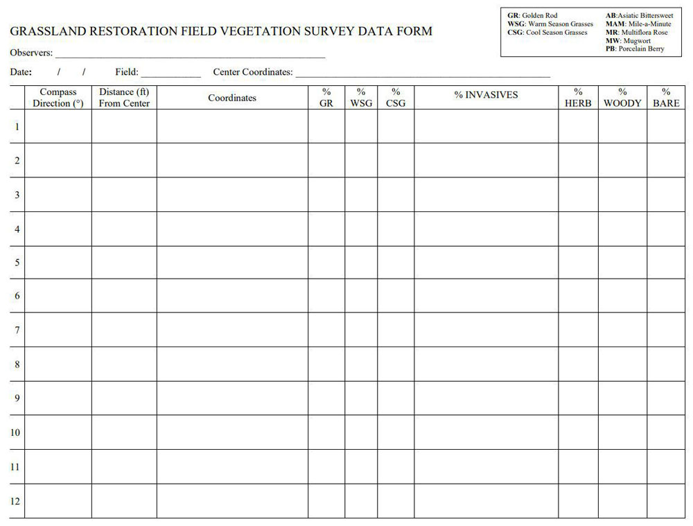
Figure 2: Grassland Restoration FIeld Vegetation Survey Data Form.
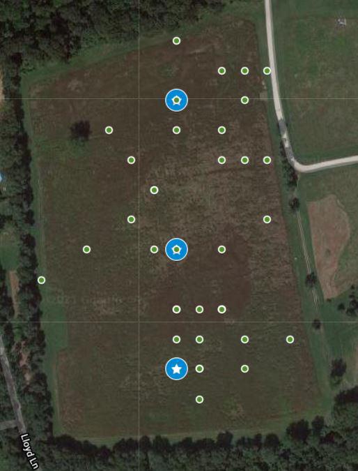
Figure 3: Grassland Restoration Field vegetation survey data collection points. Blue stars indicate the center points of each field, green dots indicate data collection points.
Pre-restoration data collection: In August of 2011 prior to the start of the restoration project, vegetation surveys using the belt transect method were completed in all three fields. Each transect line contained 15 circular one-meter diameter sampling stations. The longitude and latitude of each sampling area was recorded along with the percentage of the major vegetation types. The results of these surveys showed that the existing vegetation was composed of at least 50% invasive plants. In addition, the surveys confirmed that woody vegetation dominated in two out of the three fields.
Results
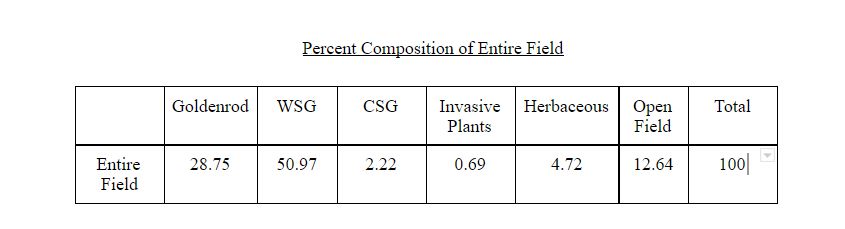
Based on the modified walkabout vegetation transect, total composition of the 30-acre Grassland Restoration Field (Table 1) consisted of mostly warm season grasses (48.19%), followed by goldenrod (26.25%) and bare ground (21.53%). Less than 2% of the vegetation sampled was herbaceous growth, while invasive plant presence was low at 1.53%. Less than 1% of the sample consisted of cool season grasses and there were no woody plants observed.
Total Average Composition
Warm Season Grasses
Goldenrod
Bare
Herbaceous
Invasives
Cool Season Grasses
Woody
Figure 4: Total average composition of Grassland Restoration Field.
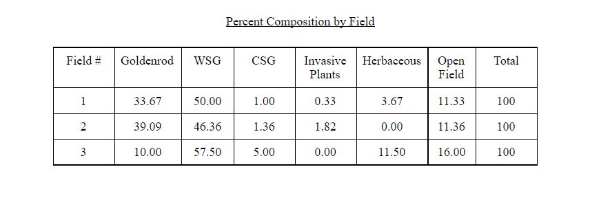
| % Goldenrod | % WSG | % CSG | % Invasive | % Herbaceous | % Woody | % Bare Ground | |
| Field 1 | 37.9 | 49.6 | 1.3 | 0.2 | 1.3 | 0 | 9.8 |
| Field 2 | 30.8 | 41.3 | 0.4 | 2.5 | 0 | 0 | 25.0 |
| Field 3 | 10.0 | 53.8 | 0.4 | 1.9 | 4.2 | 0 | 29.8 |
| Total | 26.3 | 48.2 | 0.7 | 1.5 | 1.8 | 0 | 21.5 |
Table 1: Average percent composition of sampled locations.
Vegetation Composition Per Field
Warm season grasses had the highest average occurrence in all fields followed by goldenrod in field 1 (37.9%) and bare ground in fields 2 and 3 (25% and 29.6% respectively). The transect showed that all fields lacked woody plant growth and had similar percent composition of invasive plants and cool season grasses. Field 3 had the highest occurrence of herbaceous plants (4.2%) and the lowest occurrence of goldenrod (10%) (Figure 5; Appendix A, B, and C).
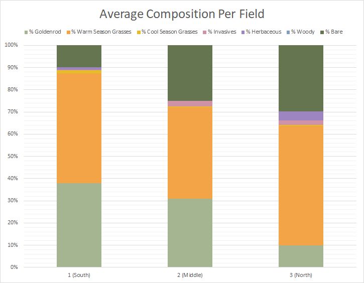
Figure 5: Average percent composition of sampled locations graphed.
Invasive Species Composition
Of the 1.53% invasive species surveyed throughout the 30-acre field, Canada thistle (C. thistle) occurred the most (49%), followed by mile-a-minute (MAM) (42%), and mugwort (MW) (9%).
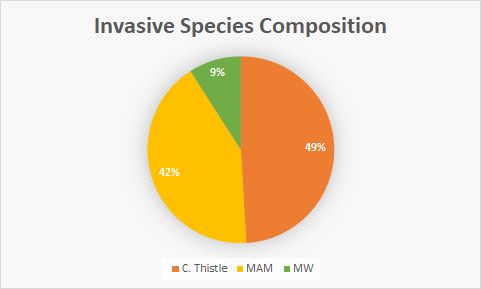
Figure 6: Invasive Species Composition.
Discussion
1. Managment
Since 2017 the Grassland Restoration Field has been mowed once annually in early spring to prevent woody plant growth, thereby inhibiting ecological succession. Management of invasive species continues throughout the growing season by means of the “search and destroy” method. This method involves walking the field in search of invasive plant infestations, marking those infestations, recording the coordinates and carrying out necessary management. The management method will be based on the plant species. (Figure 7).
Based on the search and destroy monitoring and management technique, it is recommended that annual mowing should continue early in the growing season. In order to maintain the integrity of the Grassland Restoration Field as a habitat for wildlife, the tools and timing of management should be carried out based on life history characteristics of the invasive species being managed. It is recommended that mile-a-minute (Periscaria perfoliata) be hand pulled or raked in early June before flowers and fruit develop. Mile-a-minute is an annual vine, with small barbs covering the leaves and stems that allows it to overtake and cover other plants. Removing this species early will hinder its ability to form a monoculture and forgo the need to bag flowers and fruit preventing germination. Mugwort (Artemisia vulgaris) infestations should be weed whacked several times beginning early July before the stems become woody. Scattered Canada thistle (Cirisium arvense) flowers can be hand-clipped and bagged to prevent the spread of seeds. Large infestations of C. arvense forming a monoculture should be mowed before flowers develop in July.
Figure 7
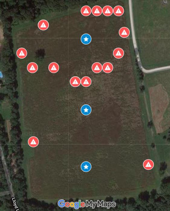
Figure 7: Non-native invasive plant infestations mapped. Blue stars indicate center points of each field, red hazard symbols indicate infestations mapped during search and destroy management.
2. Vegetation Transect
Compared to the prior walkabout vegetation survey, the modified walkabout method can allow for the collection of data points that encompass more of the Grassland Restoration Field. However, both methods produced similar overall vegetation composition results. The 2020 vegetation results were similar in percent composition of each of the six categories. The 2020 vegetation results table is provided in Appendix D. Based on observations in the field, the 2021 vegetation protocol provides an adequate estimate of the average plant composition but was limited in that it was unable to capture all invasive infestations known to be present. It is the opinion of the authors that the invasive species percent composition results may be underestimated based on field observations.
This year’s results could have been improved with additional vegetation transect trials. Varying methods of vegetation data collection may increase the accuracy of vegetation composition data throughout the life of the restoration project. Search and destroy monitoring data should be reported along with the annual vegetation survey results to ensure a more comprehensive representation of the vegetation composition throughout the Grassland Restoration Field to guide management decisions.
Appendix
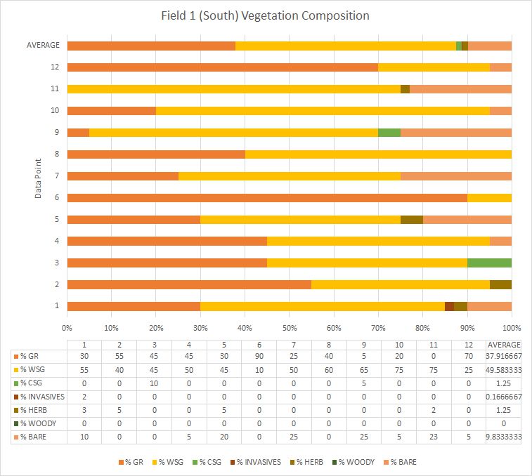
Appendix A: : Field 1 (South) Vegetation Composition. This table shows the average composition estimated by the 12 data points collected. Field 1 vegetation consisted of mostly warm season grasses (49.58%), followed by goldenrod (37.92%). Nearly 10% of the field consisted of bare ground, cool season grasses and herbaceous plants comprised 1.25% each, and invasives made up less than half a percent.
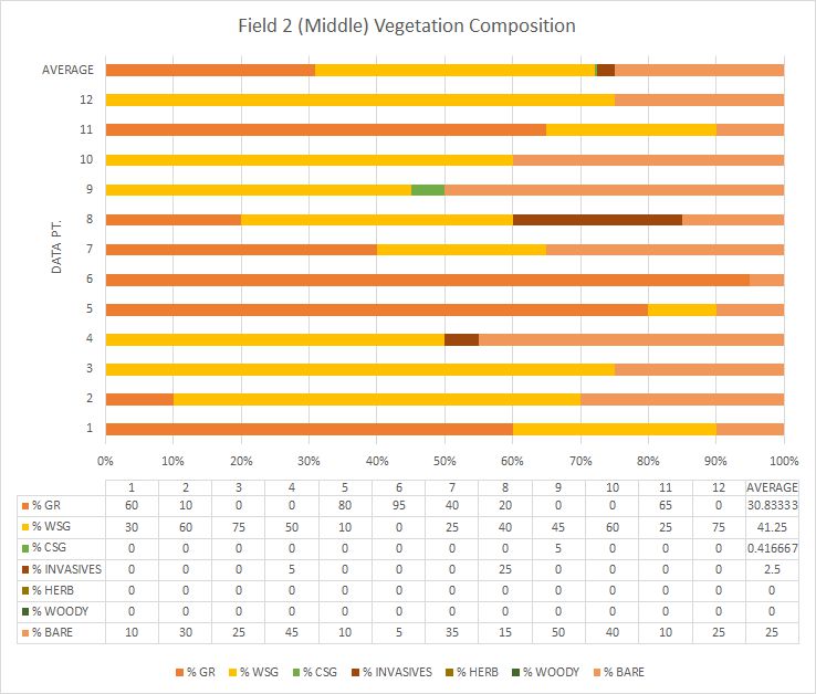
Appendix B: Field 2 (Middle) Vegetation composition. This table shows the average composition estimated by the 12 data points collected. Field 2 vegetation consisted mostly of warm season grasses (41.25%), followed by goldenrod (30.83%). 25% of field 2 was bare, and 2.5% of the vegetation sampled were invasive. No woody or herbaceous plants were observed in this field.
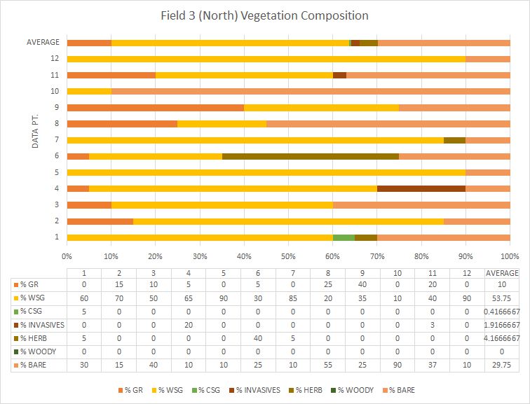
Appendix C: Field 3 (North) Vegetation Composition. This table shows the average composition estimated by the 12 data points collected. Field 3 vegetation consisted of mostly warm season grasses (53.75%), followed by bare ground (29.75%). 10% of the vegetation sampled in this field was goldenrod, less than 5% was herbaceous, about 2% was invasive, and less than 1% were cool season grasses. No woody vegetation was observed.
Appendix D: 2020 Restoration Field Transect Data
Grassland Restoration Project Phases
- Project Overview
- Phase 1 - September through November 2011
- Phase "1.5" - Summer 2012
- Phase 2 - December 2012 through September 2013
- Phase 3 - March 2014 through Spring 2015
- Second Year of Establishment 2016
- Third Year of Establishment 2017
- Fourth Year of Establishment 2018
- Aerial Photos of Field
- Grassland Management Plan
- Vegetation Survey Report of Grassland Restoration Field